
Tran’s Martial Arts
![]()
![]()

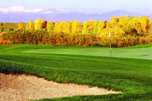
One Of The Great Public Venues In The Cherry Creek Valley Is CommonGround Golf Course
by Mark Smiley
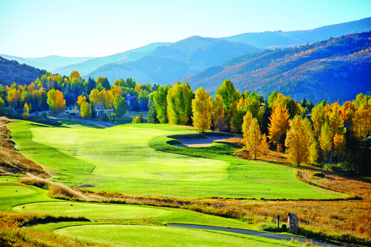 Now that summer is in the rear-view mirror, it is time to winterize the lawn mower, make sure the snow blower starts, and put away the golf clubs. Not so fast on the golf clubs. Autumn is a great time of year to golf. The courses are less crowded, the green fees are less expensive, and the fall colors in Colorado are spectacular.
The Colorado Golf Association (CGA) has many courses in its directory that feature fall golf. The CGA’s purpose is to represent, promote, and serve the best interests of golf in the state of Colorado, and has been throughout its history. The organization is the official representative of the United States Golf Association (USGA) for the state of Colorado.
The Colorado Golf Association (CGA) was established in August 1915. The CGA’s first official function was to formally take over the administration of the state’s amateur match play championship, which started in 1901. This tournament is still conducted by the Colorado Golf Association, making it the oldest golf tournament in the state of Colorado.
Today, over 43,000 men and 17,000 women are members of the CGA and the Colorado Women’s Golf Association (CWGA). Those that have a handicap are eligible to be members of the CGA or CWGA and those that do not can set one up at a course that is owned by the CGA, CommonGround.
CommonGround, located in Aurora and in proximity to Glendale, is an affordable championship course that opened in 2009 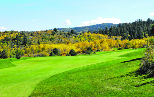 and was designed by world renowned golf course architect Tom Doak. Doak has four courses ranked among the top 100 in the world according to the “Top 100 Courses in the World” list compiled by Golf Magazine. Ballyneal Golf Course in Holyoke, Colorado, is one of those four courses.
Members of the CGA get 25 percent off their green fees at CommonGround and becoming a member is $55 annually. In addition to its 18-hole course, CommonGround also features a 9-hole Par 3 course. This is designed for juniors or seniors who want to get a fast game in and practice. CommonGround allows anyone 18 years of age or younger to golf the 9-hole Par 3 course at no cost. Adults are $10.
CommonGround is not only a championship course at an affordable rate but will serve as the stroke play co-host course for the 2019 Mid-Amateur.
Golfing in the fall is often overlooked but the  fact of the matter is that fall has the least precipitation of the non-winter months, has cooler temperatures, and is the most scenic time of the year. “Fall is the most beautiful time of the year in Colorado,” said Aaron Kellough, Director of Communications for the CGA. “If you want to get up in the mountains in late September or early October when the aspens start changing, it’s unbelievable.”
Some of the more technical reasons why golf in the fall works well is the ground is harder and drives go further. It gives golfers better chances to score. Courses are also less crowded which can make for a more enjoyable experience.
“This fall is an opportunity to play three courses that you won’t play again in the same way,” said Ryan Smith, Director of Development for the CGA. “Now is the time to go see City Park before the new design and for those who love the history and the past, get over to Fitzsimons and get over to Park Hill because the future is changing for them.”
Fall is also the time of year that smaller charities will host golf tournaments due to the prices being lower. It’s a good time to work on one’s game and have fun without a lot of the pressure that exists in the summer. Members of the CGA can post scores even if they retreat for the warmer temperatures of Arizona or Florida in the fall and winter.
To learn more about the Colorado Golf Association or to join, visit www.colora dogolf.org. A list of all 240 Colorado courses to play in the fall can be found on the website.
 by Mark Smiley
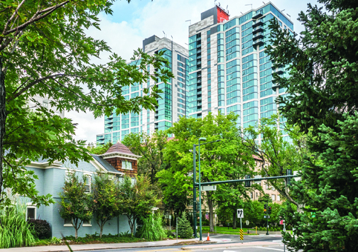
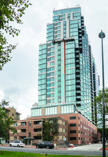
The unrelenting urbanization of the Cherry Creek and Country Club neighborhoods goes on unabated. The Cherry Creek Shopping Center announced that it had terminated the lease of the Safeway store on the northeast end of the mall where it had been a tenant for over a half century. The Shopping Center is separated from the the gigantic and highly controversial Country Club Tower and Gardens (the “Tower”) by the Denver Country Club green space.
The Tower is, in fact, two 30-story twin skyscrapers that block the view of the mountains for significant Cherry Creek and Country Club areas. The buildings have 533 apartment units, but inadequate parking according to experts which causes the overflow to jam the local streets. The Tower charges premium prices with small studio apartments going for $1,438 and two bedroom two bath units leasing out at $2,151.
With the help of the politically connected real estate lawyer Tom Ragonetti and the highly controversial and widely despised former City Councilman Chris Nevitt, developer Pat Broe received all of the applicable zoning, density and height restrictions waived by the City Council notwithstanding adamant opposition from local neighborhood groups. Critics charged that the parking provided is grossly inadequate and will result in the overflow making on-the-street parking difficult if not impossible on certain days. The Tower looms over the two and three story structures in the West Washington Park area. The massive Towers are slowly being occupied and are anticipated to create traffic nightmares on South Downing Street and Speer Boulevard.
One West Washington Park resident Pam Johnson stated, “Our neighborhood’s misery and degradation is Pat Broe’s monetary profit.”
On the other side of the Denver Country Club, Nick LeMasters, the general manager of the Shopping Center, in a press release stated that: “This move underscores the changes happening in the retail sector and the Cherry Creek shopping district as well as our commitment to Cherry Creek Shopping Center’s continued success as the region’s premier shopping destination.”
In a telephone interview with the Chronicle, LeMasters indicated that the Shopping Center had already budgeted a significant investment to redo and update the northeast portion of the Shopping Center where Safeway and Rite Aid wer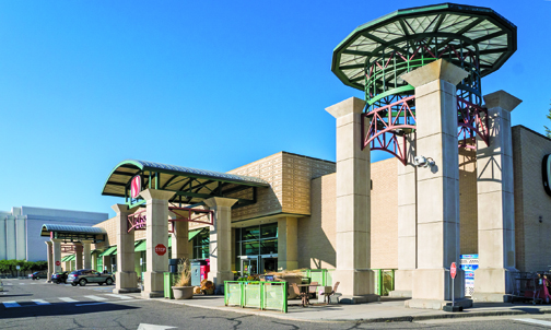 e once located. He also stated that the Shopping Center had longtime contractual commitments with a new tenant or tenants to take over the space after a complete redo of the area. LeMasters opined that a public announcement on the new tenant or tenants would likely occur late this year or early 2018.
The City and County of Denver has significantly reduced the parking requirements for new projects in the Cherry Creek and Country Club/West Washington Park area on the theory that it will cause people to abandon automobiles and take bicycles or public transportation instead, notwithstanding the fact there is no pub lic transportation in this area of the city beyond RTD buses.
The lack of parking in Cherry Creek North due to minimal parking requirements by the City and County of Denver caused the Cherry Creek Shopping Center to install an elaborate paid parking system for anyone visiting the mall with a car for more than one hour. The paid parking resulted in a dramatic public outcry. (See Glendale Cherry Creek Chronicle April 2017 front page story “Denver City Planning Choking Cherry Creek Businesses.”)
While it has been steadily rumored that the Shopping Center intended to construct an apartment house or condominium on a portion of the Shopping Center’s land, General Manger LeMasters reiterated that was simply not true and that the Shopping Center was absolutely committed to being the premier retail shopping center in all of Denver and Colorado.
In fact, Safeway expressed a hope that it may return in some form to the Shopping Center, declaring, “We hope to be given an opportunity to return to the area as the mall considers redevelopment plans over the next several years.” Safeway’s long-term lease had terminated back in December 2015 and the store was apparently on a month to month basis since that time. Back in May 2015 Safeway told the Chronicle that, “We look forward to serving our customers in this neighborhood for years to come.”
The Cherry Creek area was once considered a low density and quaint area, but that is all in the past. It is expected that downtown Denver and the Cherry Creek area will be merged. Already Speer Boulevard from Downing to downtown is becoming canyon-like with increasing high buildings crowding both sides of the road.
It is anticipated that the single-family homes in the Country Club area will disappear similar to what happened to once stately homes along Sherman Street and Colfax Avenue 100 years ago. It is also anticipated that the Denver Country Club which has been at its location since 1905 will move outside the City and County of Denver as it is slowly surrounded by massive apartment buildings.
Critics indicate that Denver under Mayor Hancock has ceased to be a “Cow Town” but what will replace it will be a typical high density and, in many areas, an unpleasant concrete jungle.
Some Residents, Users Say The Revamped Loop Road Completed This Summer Is A Travesty
by Glen Richardson
 Denver’s Washington Park was acquired in increments between 1899 and 1904 and designed in stages by Reinhard Schuetz as a green space of lakes, gardens, trees, open area and vistas to be peacefully and quietly enjoyed by the public. “Denver’s Parks & Recreation has un-greened the park by painting red, green and white lines on pavement everywhere and installing controlling signs and stanchions to herd pedestrians, facilitate autos and especially bicycle passage,” declares resident Frank Hegner.
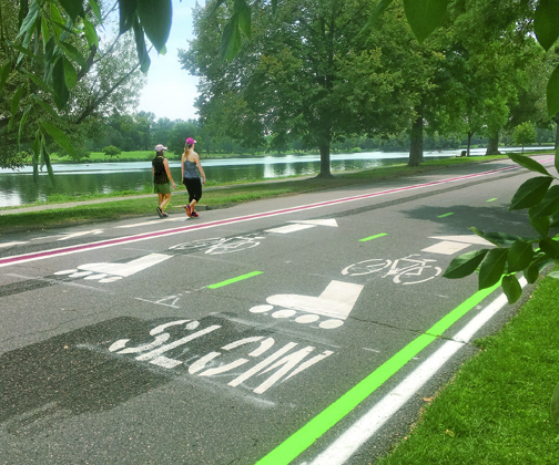
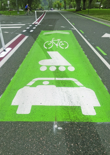
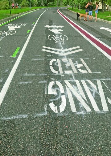
Hegner is talking about the 2.2-mile stretch of pavement known as the Loop Road that encircles the park. Changes and a new addition to the route completed this summer threw him and hundreds of other park users for a loop. He tells the Chronicle, “It is only a matter of time before someone is seriously hurt in these merging, confusing lanes of unsightly, costly insanity.”
It is the addition of a third lane not familiar to pedestrians and bicyclists that upset users the most. It’s a “bicycle alley” created by the city as a new fast lane designed especially for them, many tell the Chronicle. “You’d think there was a race track out there,” says David Matthews. He should know, he’s been walking and pedaling the route for 45 years and is a board member of the West Wash Park Neighborhood Assn. In addition to the fast lane the city has painted 150 new stencils on the asphalt path, installed 100 vertical signs explaining the new layout and erected a series of barriers to block cars from turning onto the loop. All at a cost of nearly a quarter of a million dollars.
Political Process
Denver Parks & Recreation’s response is that the changes were made based on comments from residents. “It’s not something we invented,” retorts project supervisor Jason Himick. It is true the parks department listened to residents at three public meetings plus published a 100-page report outlining the plans. In rejoinder, many users tell the Chronicle, “It’s part of the political process whether for a proposed urban development or planned park changes, but the City’s strategy policy always remains unchanged.”
One unidentified speaker at the public meetings even appeared to warn attendees that Parks & Recreation were only practicing a political process: “I’ve had enough experience in the world and as an attorney to know that once consultants are hired, somebody has made up their mind to do something. I would urge that as little as possible be done.” Belinda Bagley who lives on South Franklin says the most accurate statement made by department consultants during those meetings was that the majority of people who use the Park were satisfied with it and did not wish to see it changed. At those meetings she pointed out, “Most of the time the park is not crowded. There are a few peak times when congestion might cause various difficulties, but that is the exception rather than the rule.”
There are, of course, those that are happy with the changes including Tim McHugh, President of FANs (Friends & Neighbors of Wash Park). He says the process included, “a wide variety of park users who consider th e best interests of all who use the Loop Road.” Frank Miltenberger — another park stakeholder — believes the process was fair, though not everyone got everything they wanted.
Safety Concerns Overlooked
The single thing residents and users at the public meetings seemed to agree on was that speed is a worry. “Slow is safe,” many suggested. Furthermore, a number of people spoke about concerns, even fear, of bicycles moving at fast speeds. “Anyone moving at speeds that do not allow for quick stops or turns is a concern. The slower the safer,” warned Glen Legowik.
Matthews — the FANs board member who objects to the changes because of bike speed — personally witnessed a serious accident when a bicyclist entering the park from Marion Parkway hit a car coming out. He’s seen less serious altercations among bicyclists and pedestrians when one strays into the other’s lane. “There just need to be a few things that say, ‘slow down, it’s not a race track.’ I’m not at all against people riding their bikes here, but we’ve got to have some way to do it safely.”
As for the signage, Humboldt Street’s Jenna Moore admits the former one-way arrows confused people. But she says all that was needed was to paint an additional arrow pointing the opposite direction where the original pedestrian arrows were painted. Similarly, signage that informed cyclists that they need to stay in their lane would have helped.
Baffling Symbols
For Washington Park Loop Road bikers, walkers, runners, rollerbl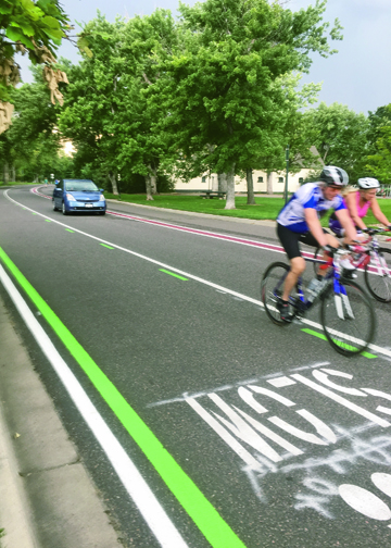 ading, and dogs this is what the lanes ahead now look like: The two outer lanes are for one-way wheeled traffic only, each marked by a bicycle and a rollerblade stencil. Unfortunately, however, many are confusing the rollerblade symbol as a footprint-marker indicating use for pedestrian traffic.
The outermost lane is slower; the middle lane is for passing. In at least one stretch the middle lanes open up to car traffic, too. The pedestrian lane, closest to the park interior, has a pedestrian symbol and is reserved for foot traffic and leashed dogs walking in both directions.
Critic Matthews suggests that adding the new lane has squeezed pedestrians to one side. Furthermore, he notes the entire metro area has 10-foot bike paths for two-way traffic but all of a sudden 18-feet is required in Wash Park.
Flawed Process
Ultimately many Washington Park residents feel they were in some sense conned once again by the Hancock Administration generally and the Parks & Recreation Department specifically. Many believe that the administration is attempting to control traffic by making owning an automobile a difficult and expensive proposition.
The transportation alternative preferred by the administration for most people is either bicycles or public transportation. Thus when the Wash Park Loop was being conceptualized the city’s preference for bicycles overrode any input from local residents at the meetings concerning pedestrian travel.
What were all those meetings about?” demanded Matthews of the Deputy Manager of Parks & Recreation Scott Gilmore, who off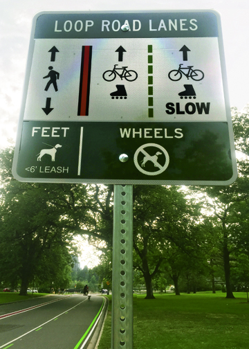
ered to “remove some curb” at the narrowest points in the pedestrian lane. (Parks & Recreation later did this.)
But Matthews was angry. “Sc
ott, you took the side of the bikes. They have 18 feet! What about the people?”
Gilmore finally retorted that there were many other paths for people to walk on in Washington Park.
“What I’ve found in this job,” Gilmore said wearily, “is that you can never please everyone. Never. They wanted a safer road. It is so much safer.”
Gilmore did acknowledge he could have “communicated more fully” at various points. “But nobody likes change.”
Back in 2014, the stakeholders asked that the Loop Road’s essential nature not be changed — and that everyone who wanted to use it be accommodated.
It appears Parks & Recreation saw both things weren’t exactly possible. Residents argue that with more honest communication, stakeholders could have been true partners in envisioning the outcome — instead of, as Matthews feared, “being just used to show there was public input.”